Our Location today is North Ranch, Congress,
Arizona, U.S.A.
Due to the temperature
dropping down near 45 F (7 C) last night we chose to sleep with
the windows closed. Even though we slept soundly we both felt like we could
have stayed in bed longer. I was up by 7:30 and Kathy before 8:00. If we were still
tired why would we get up early, you might ask yourself. Because we had plans
to go exploring today and we didn’t want to waste our time just sleeping.
We still had breakfast and
our Coffee/Tea while reading at the Computers but even that time we
shortened down. We had our inside chores finished and packed some Hiking Equipment and supplies making
certain that we’d make it safely Home by the end of the day. All that planning
and gathering took some time and since it was past 10:30 Kathy suggested an
early lunch before leaving.
The Weather Network even said
today’s high would reach 72 F (22C) this afternoon but when we stepped
outside the Trailer and that Cold North Wind hit the both of us we were
scrambling back inside for our jackets.
 |
| Back on Highway 89 heading up to Yarnell. |
Armed with instructions to
a local site that Al from Travel with the Bayfield Bunch had sent Kathy we
were determined we would find it on our own. We didn’t stop at the Office here
at North
Ranch to ask for instructions
like Al suggested, instead we headed back into the town of Congress where we looked to see
a street sign with the name Date Creek Road on
it. For well over a half hour we traveled the neighbourhood around Ghost Town Road before heading down Highway 71 towards Highway 93. During that time I had Kathy read
me the instructions a few times before realizing we were going the wrong way.
 |
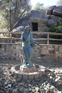
| Praying in the garden. |
Going back through Congress we
crossed Highway
89 only to come face to face with
a sign on a fence that said “Private
Property”. Reading the instructions again we started heading east on 89 nearly
stopping at every cross road there was with no luck. What happened was we ended
up driving the winding highway all the way back up the mountainside to Yarnell.
Once the Two-Lane Road becomes a Divided Highway there is no turning
back and you have to go the distance.
 |
| Jesus dies on the cross. |
After driving through the
town, we turned around and started heading back when we spotted a sign to the Shrine of St.
Joseph. Kathy had read about it and thought that we should check it
out. The road wound its way through a residential area until it came to an end
in a small parking lot that could hold a dozen vehicles at best. There are no
fancy signs but looking closely at the fence there was a Painted sign saying Shrine of St Joseph.
 |
| On the Third Day he has risen. |
Leaving the truck as you
walk along a path you are first met with a solitary figure at a long table
about to break bread at the Last Supper.
Seeing beyond him you start an ascent up the mountainside following a path that
is in need of repair as you begin the “Stations
of the Cross”. In the Christian Bible
they lead to the Crucifixion, Death and Resurrection of Christ. It was well laid out and displayed. It is Not Handicap Accessible so if
you have difficulty climbing uneven stairs you might pass on this. We helped contribute to their maintenance fund
before leaving.
 |
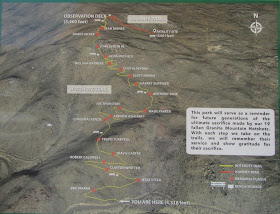
| Pictures from the Bulletin Board at the Granite Mountain Hotshots Memorial State Park. |
As we headed back to the Highway
it didn’t take long before we were leaving Yarnell behind. Driving on the westbound lane
of Highway
89 we momentarily pulled over at
the Granite
Mountain Hotshots Memorial State Park. This is in memory of the Nineteen Hotshots Firefighters who lost
their lives on June 30th 2013
trying to save homes in the Yarnell region. This is a difficult Seven Mile in and out Hike not meant for anyone with physical
limitations.
 |
| Are we there yet? |
 |
| Someone marking their spot. |
We passed on that and
headed back towards Congress. Not having the trailer pushing us
down the mountain road like the last time helped but Kathy still felt like she
was getting Sea-Sick from all the
curves in the road. We finally pulled in to the Family Dollar parking lot trying to figure out where Date Creek Road was. I didn’t mention earlier that we had brought
our GPS along in case we got lost
somewhere. When it asked for an address we entered 00 and within seconds it was
leading us back towards Yarnell. We had been looking for the road by name
but our GPS knew it as CR-62.
As soon as we crossed the Cow-Guard
there was the name Date Creek Road.
 |
| Notice the clouds forming in the sky. |
 |
| Lots of daily trains out here. |
 |
| Training Horses. |
We had been warned that
this would be a slow drive but that our Truck could make the trip. What Al didn’t count on was our tires would contain 80
PSI of air in them. This Washboard Road
had the Truck Bouncing so much that I
had to steer it like I was driving on Snow
Covered Ice and we were traveling around Seven MPH. Exactly as Al had mentioned at Six and a Half Miles from the Highway there was Skull Rock. There was no way for
us to cross the Railroad Tracks but with
the use of Zoom on the Cameras we got a good view. Skull Rock like many other rocks had been painted to
resemble different things in the area. A rock on the Highway painted to look like a
giant Frog or a small rock by the
side of Date
Creek Road that looked like
rearing White Stallion.
 |
| Skull Rock. |
 |
| Painted on the side of a Rock |
Turning around in a Rancher’s Driveway the trip back to the
Highway
seemed smoother and at one point we were actually doing Fifteen MPH. We had a number of locals pass us by and leave us in
their dust. Their vehicles had Wide Tires
that looked like they were low on air to smooth out the Washboard Road. We loved every minute of our Adventure today and we still have a couple more of those to check
out.
 |
| Deep Fried Breaded Zucchini after we had eaten half the order. |
 |
| French Onion Soup |
 |
| Chicken/Bacon Quesada |
Heading back towards Congress
Kathy suggested we eat at Nichols West again
and since it was already after 4:00 I didn’t object. Today the parking lot was
full but we arrived as someone else was pulling out. Inside it was all
different servers then the other day. We splurged and had Deep Fried Breaded Zucchini appetizer that we share. Then we had French Onion Soup and a Chicken/Bacon Quesada for our meals. It was all Delicious and we
won’t be hungry until breakfast.
The sky was full of dense clouds
when we headed back to North Ranch to
the point it went from Dim to Dark
instead of the usual Arizona Sunset. Not Quite Sure what we’re doing tomorrow but I know we’ll be back
exploring on Thursday. Thanks for following along, feel free to leave a comment and click on
the pictures to enlarge them. Be Safe and Enjoy!
It’s about time.
Krackers
Words of Inspiration
God could not be everywhere, and therefore he made
mothers.
Rudyard Kipling, English Author


Sounds like the GPS saved the day. Sometimes they do work.
ReplyDeleteTake care, be safe,
Deb
Hmmmmm, guess my memory is slipping more than I thought it was. Can't remember sending those kinds of directions. Yes that washboard road to Hillside is terrible but gets better the further you go.
ReplyDeleteNow that was a day of adventure. That road must have gotten your truck mighty dusty.
ReplyDeleteIt sounds like a great day with several interesting stops!
ReplyDeleteThose painted rocks are amazing!!! What a fun trip!
ReplyDeleteLooks like a nice adventure! Those painted rocks were pretty cool!
ReplyDelete